Temecula Valley sits in one of California's highest wildfire-risk counties, with updated 2025 fire-hazard maps and recent evacuation events confirming the exposure. California's Safer from Wildfires regulations now require insurers to offer mitigation discounts of roughly 4–40%, and new grant programs can offset hardening costs for eligible homeowners.
What do Temecula Valley homeowners need to know about wildfire risk and insurance in 2026?
Temecula Valley sits inside one of California's highest wildfire-risk counties, and the insurance market has responded accordingly. California's Safer from Wildfires regulations now require insurers to offer verified mitigation discounts ranging from roughly 4% to 40%, recent state laws have added grant funding for qualifying home-hardening projects, and the 2025 fire-hazard maps updated specifically for Temecula show exactly which neighborhoods carry the most exposure. The short version: your risk is real, your premiums reflect it, and the steps you take on your property now have a direct, documented impact on what you pay.
Key Takeaways
Riverside County, including Temecula Valley, is classified as one of California's highest wildfire-risk regions, according to a November 2025 analysis of updated CAL FIRE Fire Hazard Severity Zone maps.
California's Safer from Wildfires regulations require insurers to offer discounts of roughly 4–40% tied to verified mitigation work, per a March 2026 California Department of Insurance briefing.
The Henderson Fire (May 2025) and Tornado Fire (September 2025) both triggered evacuation warnings for neighborhoods in or immediately adjacent to the Temecula area.
The California Safe Homes Act (AB 888) created a grant program to help eligible homeowners fund fire-safe roofs and Zone Zero improvements, which are the same upgrades that unlock insurance discounts.
Temecula's updated Fire Hazard Severity Map, released in March 2025, is the starting point for understanding your specific property's risk classification and what mitigation may be required or rewarded.
How serious is the wildfire risk in Temecula Valley, and how close has fire come recently?
The risk here is not theoretical. A November 2025 analysis of updated CAL FIRE Fire Hazard Severity Zone maps found that large portions of Riverside County, including communities near Temecula, are classified as "very high" wildfire risk. That puts Temecula Valley in the same tier as some of the most fire-exposed areas in the state.
The City of Temecula made this official in its own backyard. In March 2025, the city released updated Fire Hazard Severity Maps reflecting the latest CAL FIRE hazard classifications for areas under city jurisdiction. Homes closer to the Santa Ana Mountains, canyon corridors, and wildland-interface edges are more likely to land in higher hazard tiers than homes in more built-out interior neighborhoods.
And the fires have not stayed abstract. In May 2025, the Henderson Fire in Riverside County triggered evacuation warnings for neighborhoods near Pechanga Road, Pala Road, and Anza Road, all within the broader Temecula area. Then in September 2025, a CAL FIRE Tornado Fire incident update listed evacuation warning zone TMC-2249, a Temecula-designated zone code, meaning fire activity was close enough to trigger formal alerts for Temecula residents.
The seasonal pattern compounds this. According to the city's Temecula Ready emergency-preparedness document (February 2025), dry conditions and Santa Ana winds drive the valley's highest fire-danger periods, with Santa Ana events peaking in fall and early winter. Late summer heat extends the window. In August 2025, a heat wave across the Inland Empire produced red flag warnings across Riverside County, confirming this is a recurring, not rare, pattern.
I tell every buyer considering a home near the wildland interface to look at the FHSZ map before they fall in love with a property. Insurability is part of the cost of ownership, and understanding what zone you're in is the first step to understanding what you'll pay to protect it. If you want a broader picture of what ownership costs look like here, the hidden costs of owning in Temecula post covers the full picture.
How Temecula Valley's risk compares across the market
The insurance pressure isn't uniform across the valley. Recent local market data shows homes selling across a range of price points and timelines, and the wildfire-risk profile of a given area is one factor shaping both insurance costs and buyer demand. The table below reflects aggregated public listing data for the trailing 90 days as of September 2026. An individual home's value varies by condition, street, and timing.
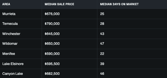
Areas with longer days on market, like Winchester, Wildomar, and Canyon Lake, tend to have more wildland-interface exposure. That doesn't mean they're bad investments, but it does mean insurance costs and mitigation requirements deserve a closer look before you commit. Understanding what daily life and property ownership actually look like in each community matters as much as the price tag, which is something I cover in more depth in the living in Temecula guide.
How do California's insurance rules and new laws affect what Temecula homeowners actually pay?
California has moved aggressively to tie insurance pricing to wildfire mitigation, and the rules in place as of 2026 have real, direct implications for what you pay, whether you can keep a private carrier, or whether you end up on the California FAIR Plan.
Safer from Wildfires discounts: what the numbers look like
Under California's Safer from Wildfires regulations, insurers are required to offer discounts tied to verified mitigation work. A March 2026 California Department of Insurance briefing on wildfire safety and insurability confirmed those discounts range from roughly 4% to 40%, depending on the scope and type of mitigation completed. That is a meaningful spread, and it means the difference between doing nothing and doing everything is not trivial on your annual premium.
The Insurance and Wildfire Safety Act (AB 1), highlighted by the California Department of Insurance in October 2025, requires the Department to regularly review and update these regulations to keep pace with advances in fire science and mitigation. This isn't a static framework. The discounts and the requirements behind them will continue to evolve, and staying current matters.
Individual carriers also file their own wildfire-mitigation discount structures with the state. The California Department of Insurance's Home Protection Safety Discounts spreadsheet shows carrier-specific credits for wildfire mitigation filed with and approved by the Department, confirming this is now a formal, regulator-reviewed pricing factor, not just a marketing promise.
The FAIR Plan, home hardening, and what to do if private carriers won't write you
In higher-risk portions of Riverside County, some standard carriers have tightened underwriting or declined to renew policies. If that happens, the California FAIR Plan becomes the fallback. The FAIR Plan introduced home-hardening discounts effective November 2024, with expanded categories in late 2025, meaning a Temecula homeowner who invests in qualifying improvements can reduce FAIR Plan premiums and potentially become more attractive to private carriers over time.
The improvements that matter most to both the FAIR Plan and private carriers include a Class-A fire-rated roof, ember-resistant vents, enclosed eaves, dual-pane tempered windows, and non-combustible perimeter surfaces. These aren't cheap upgrades, which is exactly why the California Safe Homes Act (AB 888) matters.
Grant funding under AB 888 to offset the cost of hardening
The California Safe Homes Act (AB 888), announced in December 2025, created a grant program to help eligible California homeowners fund fire-safe roofs and Zone Zero mitigation work. Zone Zero is the first five feet around your home, and it is the most critical area for ember resistance and ignition prevention. Grant funding for this work makes it more feasible to complete the mitigation that retains private insurance or qualifies for better FAIR Plan rates, and those same improvements can make a property more marketable to buyers who are paying attention to insurability in 2026.
What mitigation steps actually move the needle on risk and premiums?
The measures that reduce your actual fire risk and the ones that unlock insurance discounts overlap significantly. Here is what I walk my clients through when they ask about protecting a property in a higher-hazard area.
Zone Zero (0–5 feet from the structure)
This is the highest-priority area. Remove combustible materials from the immediate perimeter: wood mulch, shrubs, stored items, and anything that can carry an ember to your siding or under your deck. Replace with gravel, pavers, or other non-combustible landscaping. This is the area AB 888 grant funding specifically targets, and it is a core component of Safer from Wildfires guidance.
Zone 1 and Zone 2 defensible space
Zone 1 covers 5 to 30 feet from the structure; Zone 2 covers 30 to 100 feet. Both require what fire authorities call "lean, clean, and green" vegetation management: reducing fuel loads, spacing plants, removing dead material, and keeping grass mowed. The Temecula Ready guidance and carrier discount criteria both treat defensible space as a baseline, not a bonus.
Structural hardening
The specific upgrades that appear most consistently in carrier discount descriptions and FAIR Plan hardening criteria include:
Class-A fire-rated roofing (the single highest-impact structural upgrade)
Ember-resistant vents (replacing standard attic and foundation vents)
Enclosed or boxed eaves (eliminating gaps where embers can enter)
Dual-pane tempered windows (reducing radiant heat ignition risk)
Non-combustible deck and patio surfaces
Documentation is the part most homeowners skip
Under the Safer from Wildfires framework, discounts are tied to verified mitigation. That means photographs of completed work, contractor invoices, and where possible, CAL FIRE or private inspection documentation. I advise anyone doing this work to build a file as they go. Insurers are not going to give you credit for improvements they can't confirm, and having that documentation ready when you shop carriers or renew your policy is what actually translates the work into premium savings.
Every situation is different, and the right mitigation priorities for your specific property depend on your zone classification, your current carrier's requirements, and what improvements you've already made. That's the kind of conversation worth having before you spend money on the wrong thing first.
Frequently Asked Questions
Is my Temecula Valley home considered high wildfire risk, and how do I check my specific fire-hazard zone?
Start with the City of Temecula's Fire Hazard Severity Map, updated in March 2025, which shows hazard classifications for areas under city jurisdiction. For unincorporated Riverside County areas, the CAL FIRE FHSZ viewer is the reference. Homes near the Santa Ana Mountains, canyon corridors, and wildland-interface edges are more likely to fall in higher-hazard tiers than properties in built-out interior subdivisions. Checking your specific parcel before you buy, refinance, or shop insurance is the only way to know for certain.
How have recent fires near Temecula affected insurance availability and pricing?
The Henderson Fire (May 2025) and Tornado Fire (September 2025) both triggered evacuation warnings in or immediately adjacent to the Temecula area, reinforcing to carriers that this market carries active, not theoretical, risk. When fires occur in a region, insurers often tighten underwriting in nearby ZIP codes, require more mitigation documentation before writing or renewing policies, or shift some households to the California FAIR Plan. If your carrier has sent a non-renewal notice or raised your premium significantly, those events are likely part of the explanation.
What mitigation steps do insurers actually recognize for discounts on homeowners insurance in Temecula?
Under California's Safer from Wildfires regulations, discounts of roughly 4–40% are required for verified mitigation work, per the California Department of Insurance's March 2026 briefing. The upgrades that appear most consistently in carrier and FAIR Plan discount criteria include a Class-A fire-rated roof, ember-resistant vents, enclosed eaves, dual-pane tempered windows, non-combustible Zone Zero landscaping, and maintained defensible space in Zones 1 and 2. Documentation of completed work, including photos and invoices, is essential to actually receiving the credit.
If my home is in a very high fire-hazard zone, can I still get regular homeowners insurance?
It depends on your property's specific risk factors, your current carrier's appetite for the area, and what mitigation you've completed. Some standard carriers have limited new policies or non-renewed existing ones in higher-risk Riverside County areas, which means the California FAIR Plan may become your primary option. The FAIR Plan is a legitimate coverage path, and its home-hardening discounts (effective November 2024, expanded in late 2025) mean mitigation investments can reduce your FAIR Plan premium and potentially make your property attractive to private carriers over time. Pairing FAIR Plan coverage with a separate difference-in-conditions policy is a common approach for comprehensive protection.
What discounts or grants are available right now if I harden my home against wildfires?
The California Safe Homes Act (AB 888), announced in December 2025, created a grant program to help eligible homeowners fund fire-safe roofs and Zone Zero improvements, which are the first five feet around the structure. On the insurance side, California's Safer from Wildfires regulations require carriers to offer discounts of 4–40% for verified mitigation, and the Insurance and Wildfire Safety Act (AB 1) requires the state to keep those discount structures current. Check with the California Department of Insurance and your carrier directly for eligibility and current program details.
What is Zone Zero, and why does it matter for insurance?
Zone Zero is the area within five feet of your home's exterior, and it is the most critical zone for preventing structure ignition from embers. Embers landing in combustible materials directly against your foundation, siding, or under a deck are one of the leading causes of home ignition during wildfires. Clearing Zone Zero of wood mulch, shrubs, and stored items and replacing them with non-combustible surfaces is both a core fire-safety measure and a qualifying improvement under AB 888 grant funding and Safer from Wildfires discount criteria.
Wildfire risk in Temecula Valley is documented, active, and directly tied to what you pay for homeowners insurance. The good news is that the mitigation steps that reduce your actual risk are the same ones that unlock discounts and grant funding under California's current regulatory framework. Your specific situation, your zone classification, your property's current condition, and your carrier's requirements all shape the right path forward. That's exactly the kind of analysis I walk clients through before they buy or list a property here. Schedule a consultation and we'll map out what applies to your home specifically.
About Andrew Lewis
Andrew Lewis is a top-producing REALTOR® and founder of Performance Real Estate serving the Temecula Valley and greater Riverside County. Licensed since 2012, he has closed over 500 transactions totaling more than $200 million in sales, specializing in luxury homes, listings, new construction, relocation, and investor-focused real estate.
Real Broker · (951) 237-0292
Equal Housing Opportunity. Andrew Lewis, CA DRE (individual license on file), Performance Real Estate DRE 01914085 / 02022092, Real Broker. This article is general information only and is not legal, tax, or financial advice. Confirm your specific insurance costs, coverage options, and mitigation requirements with a licensed insurance professional, your closing agent, and your tax advisor. Regulated by the California Department of Real Estate.